Himalayan vs Peninsular Rivers: Essential Differences Explained
The diverse geography of India is home to two major river systems - the Himalayan rivers and the Peninsular rivers. These waterways aren't just flowing bodies of water; they're the lifelines of civilizations that have thrived along their banks for thousands of years. Having grown up near the banks of a Himalayan tributary, I've always been fascinated by how these river systems differ and shape the surrounding landscapes so dramatically.
The classification of Indian rivers into Himalayan and Peninsular categories is primarily based on their origins, with each system possessing unique characteristics that influence everything from agriculture to settlement patterns. While most geography textbooks offer dry comparisons, I've found that understanding these differences gives us incredible insight into India's cultural and ecological diversity. Ever wondered why northern Indian plains are so densely populated compared to central India? The answer lies partly in the nature of these river systems!
Understanding Himalayan Rivers: The Northern Lifelines
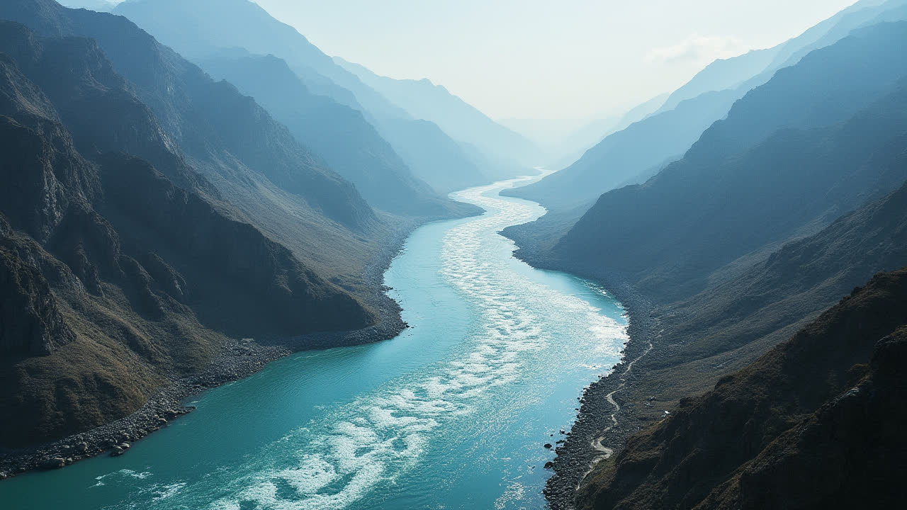
Himalayan rivers originate from the majestic Himalayan mountain ranges, often born from glacial melts high in the peaks. The three major Himalayan river systems - Indus, Ganga, and Brahmaputra - all begin their journey in these snow-capped mountains and generally flow westward or eastward before emptying into the sea. I remember my grandfather telling stories of how the holy Ganges seems to have an almost supernatural persistence, flowing strongly even during the driest months - a characteristic that's actually explained by its perennial nature.
These northern rivers are characterized by their impressive size and volume. They carve out long valleys and develop larger channels as they travel across the plains. Himalayan rivers boast vast basins and catchment areas that collect water from extensive regions. For instance, the Indus river system has a basin area of approximately 165 million square kilometers - an area so large it's difficult to comprehend without seeing it on a map. In comparison, even the largest peninsular river has a significantly smaller basin.
What makes Himalayan rivers particularly valuable for agriculture is their perennial nature. They maintain continuous water flow throughout the year, thanks to their dual feeding system - they receive water both from monsoon rains and from melting snow and ice. This reliable water supply has made the Indo-Gangetic plain one of the most fertile and densely populated regions in the world. Isn't it fascinating how geological features from millions of years ago still determine where people live today?
Geologically speaking, Himalayan rivers are considered antecedent streams. This means they've maintained their original course despite changes in the underlying rock topology. These rivers are believed to be in their early maturity stage based on their volume, velocity, and other hydrological features. Unlike their southern counterparts, Himalayan rivers frequently form meanders (those beautiful curves you see from airplane windows) and can change their course over time - sometimes with devastating consequences for settlements built too close to their banks.
Perhaps the most impressive feature of Himalayan rivers is the enormous deltas they form at their mouths. The Ganga-Brahmaputra delta is actually the largest delta in the world, a massive fertile region that spans parts of India and Bangladesh. These deltas have historically been centers of agriculture, trade, and civilization, though they now face significant challenges from climate change and rising sea levels.
Exploring Peninsular Rivers: The Ancient Southern Waterways
The peninsular rivers tell a different story altogether. These rivers originate from the peninsular plateau of India, an ancient geological formation that's been stable for millions of years. Major peninsular rivers include Kaveri, Narmada, Tapi, Krishna, Godavari, and Mahanadi. During my travels through southern India, I was struck by how different these rivers looked compared to the mighty Ganga - narrower, more contained, almost more determined in their path.
Compared to their Himalayan counterparts, peninsular rivers are considerably shorter and smaller. They have more modest basins and catchment areas, which limits the volume of water they can carry. For example, the Godavari, known as the "Ganga of the South" and the largest peninsular river, has a basin area of 312,812 square kilometers - substantial, but much smaller than the major Himalayan rivers.
Peninsular rivers are classified as consequent rivers, which means they follow the natural slope of the land. This gives them more predictable courses than Himalayan rivers. One of the most significant differences is that peninsular rivers are seasonal or non-perennial in nature. They primarily receive water from rainfall, particularly during the monsoon months, resulting in fluctuating water levels throughout the year. During my visit to the Krishna river in April, I was surprised to see how much the water had receded, leaving wide, dry banks that would be submerged during the rainy season.
These southern rivers flow through relatively shallow valleys compared to the deep gorges of their northern cousins. The peninsular plateau is characterized by hard rock surfaces that resist erosion, which means the rivers haven't been able to cut as deeply into the landscape. As a result, peninsular rivers typically have narrow flood plains, limiting the agricultural potential of the surrounding land.
Geologists believe peninsular rivers are older than Himalayan rivers and are in their mature stage of development. The hard rock surface of the plateau doesn't allow for the formation of meanders that are common in Himalayan rivers. While some peninsular rivers like Mahanadi, Godavari, and Krishna form small deltas at their mouths, others like Narmada and Tapi form estuaries - fascinating differences that reflect the diverse geology of the Indian subcontinent.
Comparing Himalayan and Peninsular River Systems
| Characteristic | Himalayan Rivers | Peninsular Rivers |
|---|---|---|
| Origins | Originate from the Himalayan mountain ranges | Originate from the peninsular plateaus of India |
| Size and Length | Larger and longer rivers with greater volume | Comparatively smaller and shorter |
| Basin and Catchment Area | Extensive basins and large catchment areas | Smaller basins and limited catchment areas |
| Water Flow | Perennial (continuous flow throughout the year) | Seasonal (dependent primarily on rainfall) |
| Water Source | Fed by both rainfall and glacial melt | Fed primarily by monsoon rainfall |
| Age and Maturity | Considered to be in early maturity stage | Considered older and in mature stage |
| River Mouth Formation | Form large deltas (e.g., Ganga-Brahmaputra delta) | Some form small deltas, others form estuaries |
| Course Characteristics | Antecedent rivers that may change course | Consequent rivers that follow land slope |
Ecological and Cultural Significance of India's River Systems
Beyond their geographical differences, Himalayan and peninsular rivers have shaped the ecological landscapes and cultural identities of their regions in profound ways. The continuous flow of Himalayan rivers has created some of the world's most fertile agricultural lands along their banks. The Indo-Gangetic plain, nourished by the Ganga and its tributaries, has been the breadbasket of the subcontinent for millennia. This agricultural productivity has supported dense populations and the rise of major civilizations throughout history.
Peninsular rivers, despite their seasonal nature, have played an equally important role in southern India. Ancient civilizations in the peninsula developed sophisticated irrigation systems, including dams and canals, to harness the seasonal flows of these rivers for agriculture. The Grand Anicut (Kallanai Dam) on the Kaveri river, built around the 2nd century CE, is one of the oldest functioning water regulation structures in the world - a testament to the ingenuity of early engineers who understood the unique challenges of peninsular rivers.
River systems in India also hold immense cultural and religious significance. The Ganga, in particular, is revered as a goddess in Hinduism and is central to numerous religious practices and beliefs. Pilgrimages to holy sites along these rivers, like Varanasi on the Ganga or Nashik on the Godavari, attract millions of devotees annually. I've witnessed the evening Ganga Aarti ceremony at Varanasi, where thousands gather to pay homage to the river - a powerful demonstration of how these waterways transcend their physical presence to become spiritual entities.
Both river systems face significant challenges in the modern era, though the nature of these challenges differs somewhat. Himalayan rivers, with their massive volumes, cause devastating floods during monsoon seasons - a problem that's being exacerbated by climate change and deforestation in the Himalayas. Peninsular rivers, already seasonal in nature, are increasingly vulnerable to drought conditions as rainfall patterns become more erratic. Water scarcity in peninsular India has become a serious concern, leading to interstate disputes over river water sharing.
The future of both river systems hinges on sustainable management practices. For Himalayan rivers, flood control, pollution reduction, and sustainable hydropower development are key priorities. For peninsular rivers, water conservation, efficient irrigation techniques, and equitable distribution of limited water resources are crucial challenges. Understanding the fundamental differences between these river systems is essential for developing appropriate strategies to address these complex issues.
Frequently Asked Questions About Indian River Systems
Why are Himalayan rivers perennial while peninsular rivers are seasonal?
Himalayan rivers maintain year-round flow because they have dual sources of water - monsoon rainfall and glacial meltwater from the snow-covered Himalayan peaks. Even during dry seasons, the melting snow and ice ensure continued water flow. In contrast, peninsular rivers depend almost exclusively on monsoon rainfall. The peninsular plateau lacks permanent snow cover and has fewer groundwater reserves due to its hard rock composition, resulting in rivers that flow abundantly during rainy months but significantly reduce or even dry up during other seasons.
Which are the major Himalayan and peninsular rivers of India?
The major Himalayan rivers of India include the Indus (though much of it flows through Pakistan), Ganga (Ganges), and Brahmaputra, along with their numerous tributaries like Yamuna, Kosi, and Sutlej. The principal peninsular rivers include Godavari (the largest peninsular river, often called the "Dakshin Ganga" or "Ganga of the South"), Krishna, Kaveri, Narmada, Tapi, Mahanadi, and Pennar. Each river system has distinct characteristics and regional importance for irrigation, transportation, and cultural significance.
How do the delta formations differ between Himalayan and peninsular rivers?
Himalayan rivers typically form extensive, fertile deltas at their mouths due to the massive amount of silt and sediment they carry from the mountains. The Ganga-Brahmaputra delta is the world's largest and most fertile delta, spanning parts of India and Bangladesh. Peninsular rivers, carrying less sediment due to flowing over harder rock and having lower water volume, form smaller deltas. Some peninsular rivers like Narmada and Tapi don't form deltas at all but instead create estuaries where the river meets the sea in a single channel. These differences in delta formation have significant implications for agriculture, fishing, and settlement patterns in coastal regions.
Conservation Challenges and Future Outlook
Both Himalayan and peninsular river systems face mounting pressures from human activities and climate change, though the nature and severity of these challenges vary. Himalayan rivers are increasingly affected by rapid glacial retreat due to global warming, which threatens their long-term perennial nature. If the glaciers continue to shrink at current rates, what happens to these mighty rivers that have been flowing continuously for thousands of years? It's a sobering thought that keeps hydrologists up at night.
Pollution presents another major challenge, particularly for Himalayan rivers that flow through densely populated urban areas. The Ganga, despite its sacred status, is among the most polluted rivers in the world, receiving untreated sewage and industrial waste from numerous cities along its course. Government initiatives like the Namami Gange program aim to address this pollution, but progress has been slower than hoped. I've seen firsthand how challenging it is to balance economic development with environmental protection in rapidly growing cities along these riverbanks.
Peninsular rivers face their own set of challenges, with water scarcity being the most pressing issue. As rainfall patterns become more erratic due to climate change, the seasonal nature of these rivers becomes even more pronounced, leading to more frequent droughts and water conflicts. The construction of dams and reservoirs has helped manage seasonal flows to some extent, but has also led to displacement of communities and changes in river ecosystems. Finding the right balance between water storage and environmental flow remains a complex challenge.
Interstate water disputes are particularly common with peninsular rivers like Kaveri and Krishna, which flow through multiple states with competing demands for their limited water. These disputes often intensify during drought years, highlighting the need for comprehensive river basin management approaches that transcend political boundaries. The recent efforts to link rivers across basins through the National River Linking Project represent an ambitious, though controversial, attempt to address water distribution challenges on a national scale.
Looking ahead, the sustainable management of India's river systems will require integrated approaches that consider the unique characteristics of Himalayan and peninsular rivers. For Himalayan rivers, priorities include protecting Himalayan ecosystems to maintain glaciers, implementing effective flood management strategies, and reducing pollution loads through improved wastewater treatment. For peninsular rivers, efficient water use in agriculture, rainwater harvesting, and aquifer recharge will be crucial for addressing water scarcity.
Conclusion: Appreciating India's Diverse River Heritage
The stark differences between Himalayan and peninsular rivers reflect the incredible geographical diversity of the Indian subcontinent. From the snow-fed, mighty Himalayan rivers with their massive floodplains to the plateau-born, rock-cut peninsular rivers with their seasonal rhythms, these water systems have shaped both the physical landscape and human civilization in profound ways. Whether it's the bustling cities along the Ganga or the ancient temples beside the Kaveri, rivers remain at the heart of Indian life and culture.
Understanding these differences isn't just an academic exercise - it's essential for addressing the unique challenges each river system faces in an era of climate change and increasing water demands. By appreciating the distinct characteristics of Himalayan and peninsular rivers, we can develop more effective strategies for their protection and sustainable use, ensuring they continue to sustain life and livelihoods for generations to come.
As I reflect on my journeys along both types of rivers - from the icy origins of Himalayan streams to the rocky beds of peninsular waterways - I'm reminded that water is perhaps our most precious resource, one that transcends the artificial boundaries we've created. These diverse river systems, each with their own personality and challenges, deserve our respect and protection as we navigate an uncertain climatic future. After all, the story of India has always been, in many ways, the story of its rivers.


Related Posts